


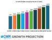
The Geographic Information Systems (GIS) market in India is projected to reach $5.01 billion by 2028 with CAGR 6.87%. This growth is due to rapid urbanization, the development of smart cities, and the increasing use of GIS in many sectors. The Indian government is promoting GIS adoption through various initiatives, and both Indian and global tech companies are contributing to this growth.
The Indian Government’s Role in GIS Adoption

India’s government is encouraging GIS adoption to improve governance and planning. The National Geospatial Policy, which aims to increase the use of geospatial data in both public and private sectors, is a major step toward this goal. Organizations like the Indian Space Research Organisation (ISRO) and the National Remote Sensing Centre are central to this effort, focusing on projects that support disaster management, land mapping, and resource optimization.
Tech companies like Google and Microsoft are also involved in India’s GIS scene, working with local companies to develop solutions tailored to India’s unique needs.
Key Features and Capabilities of GIS
GIS offers a range of features that enable users to analyze and visualize geographical data. One key feature is mapping and visualization, which allows users to create detailed maps with various data layers, in both 2D and 3D formats. This flexibility is crucial in India, with its varied geography and rapidly changing urban landscapes.
Spatial analysis is another core aspect of GIS, enabling users to perform different analyses, such as proximity analysis and network analysis. These tools help businesses and government agencies make informed decisions about urban planning, resource management, and infrastructure development.
Data management in GIS is vital for organizing and storing spatial data in formats like shapefiles, geodatabases, and cloud-based data sources. Given India’s vast geography and large population, effective data management is crucial for efficient operations.
Collaboration and sharing are also significant in GIS. Users can share maps, data, and analysis results through online platforms and mobile apps, which is important in a country where collaboration across sectors is key to successful projects.
Geoprocessing and automation allow users to automate repetitive tasks and workflows. This capability is especially useful in large-scale projects where consistency and accuracy are essential.
Key Use Cases of GIS in India
GIS is widely used across various sectors in India, contributing to efficiency and innovation.
Agriculture, In India, Geographic Information Systems (GIS) are revolutionizing agriculture. By incorporating geospatial data, farmers and policymakers can fine-tune crop management, evaluate soil fertility, monitor irrigation, and forecast yields. GIS provides sophisticated tools for mapping crops, estimating crop acreage, predicting yields, and assessing crop health and damage. This technology helps stakeholders make informed decisions on crop selection, resource use, and land planning, thereby boosting productivity and sustainability.
Water management, GIS is pivotal in water management, aiding in the surveillance of water resources, watershed management, and the enhancement of irrigation systems. In India, where water scarcity plagues certain areas, GIS becomes indispensable in water resource management and assessing the repercussions of urban expansion. By harnessing GIS, authorities can make informed decisions, allocate resources efficiently, and mitigate the challenges posed by water scarcity, thus ensuring sustainable water usage and environmental preservation.
Forest Management, GIS plays a critical role in forest management, providing tools for understanding and optimizing complex forest ecosystems. GIS technology offers innovative solutions for forest classification, land management, forest health monitoring, fire detection, and damage assessment. These capabilities help stakeholders manage forests sustainably and identify suitable sites for reforestation.
Mining, The GIS platform offers industry-specific solutions for mining, addressing challenges like potential mining area identification, environmental monitoring, and asset management. Advanced analyses tools, such as 3D-based volumetric analysis, on-the-fly profile generation, and cut-and-fill analysis, provide key insights for mining planning and operations. The platform also supports route optimization, reducing transportation costs, and has in-built indices for identifying clay minerals and iron oxide, aiding in locating potential mining sites.
Healthcare, GIS technology has a significant impact on healthcare in India. By mapping healthcare facilities, tracking disease outbreaks, and analyzing demographic data, it aids in better resource distribution and healthcare planning. Location-based analysis helps identify areas with insufficient healthcare access, guiding authorities in the strategic placement of new facilities and the efficient allocation of resources. During health crises, GIS can track disease spread, enabling timely interventions. The enterprise-level solution of GIS supports a range of monitoring and management activities at the organizational level.
Disaster Management, India’s susceptibility to natural disasters makes GIS a vital tool for disaster management. Spatial analysis and predictive modelling through GIS allow authorities to pinpoint vulnerable areas, assess risks, and devise contingency plans. Real-time mapping during disasters supports evacuation planning, resource distribution, and post-disaster recovery. GIS plays a crucial role in minimizing disaster impacts and enhancing readiness to respond effectively.
Transportation & Logistics, Geospatial data is indispensable in optimizing transportation routes and managing logistics. It aids companies in minimizing fuel costs, refining delivery schedules, and optimizing fleet operations. Through the analysis of traffic patterns and road conditions, businesses can design efficient routes and mitigate delays. This data-driven approach enhances overall operational efficiency, leading to improved customer satisfaction and reduced environmental impact.
Tourism, Geospatial data enhances the tourism journey by offering intricate maps and insights into attractions, lodging options, and noteworthy sites. It facilitates personalized travel arrangements, empowering tourists to tailor their itineraries to their preferences. Moreover, it enables tourism officials to grasp visitor trends and regulate tourist influxes efficiently. By leveraging geospatial data, destinations can optimize their offerings, enhance visitor experiences, and ensure sustainable tourism management for both travellers and local communities.
Utility companies, GIS is instrumental for utility companies in mapping and overseeing infrastructure such as power lines, gas pipelines, and water distribution networks. It facilitates asset tracking, maintenance planning, and swift response to outages, thereby guaranteeing dependable service for millions of customers. Through GIS, utility providers can optimize operations, pre-emptively address potential issues, and uphold service reliability, thus fulfilling their critical role in supporting communities and industries.
Infrastructure, GIS is a cornerstone tool for infrastructure planners and engineers, aiding in the design and administration of transportation networks such as roads, railways, and airports. It enables the planning of new construction endeavours and the evaluation of their environmental repercussions. By leveraging GIS, professionals can analyze geographical data to optimize routes, enhance traffic flow, and ensure the efficient utilization of resources. Moreover, it facilitates comprehensive assessments of environmental impacts, promoting sustainable development practices in infrastructure projects. Overall, GIS plays a pivotal role in shaping efficient, environmentally conscious transportation systems and infrastructure.
Urban development and smart cities, Geospatial techniques are central to modern urban planning and monitoring. By combining spatial and non-spatial data, GIS enables urban planners and policymakers to make informed decisions for sustainable development. It enhances the accuracy of urban plans, streamlines infrastructure management, and promotes public engagement. The GIS platform offers comprehensive solutions for smart city planning, infrastructure management, and land management, helping create well-designed, resilient cities for current and future generations.
Retail sector, GIS is employed to scrutinize customer demographics, fine-tune store placements, and strategize marketing initiatives in accordance with geographic trends. This methodology empowers retailers to make data-driven choices regarding new store launches and market targeting. By harnessing GIS, businesses gain insights into consumer behaviour patterns, enabling them to tailor offerings to local preferences and maximize market penetration. Ultimately, this approach fosters efficient expansion strategies, enhances customer engagement, and bolsters profitability within the dynamic retail landscape.
Insurance sector, GIS plays a pivotal role in evaluating risks associated with specific locations, such as flood-prone zones or earthquake-prone regions. By harnessing GIS, insurers can accurately assess and quantify potential risks, enabling them to offer tailored coverage and pricing. Moreover, GIS facilitates efficient claims management by providing spatial data for damage assessment, expediting the claims processing timeline. This approach not only enhances the accuracy of risk evaluation but also streamlines claims handling procedures, resulting in improved customer satisfaction and operational efficiency within the insurance industry.
Telecommunications companies rely on GIS for planning and overseeing network infrastructure, guaranteeing optimal signal coverage, and addressing customer service concerns. In a country as expansive as India, GIS is indispensable for maintaining reliable telecom services nationwide. By leveraging GIS, telecom providers can analyze geographical data to strategically place towers and infrastructure, ensuring seamless connectivity even in remote areas. Additionally, GIS aids in identifying areas with network congestion or service disruptions, enabling swift interventions to enhance customer experience. Ultimately, GIS serves as a cornerstone technology for delivering robust and dependable telecommunications services across India’s diverse landscape.
BFSI, GIS is invaluable for comprehending customer demographics, strategizing branch placements, and dissecting economic trends using geographic data. This insight equips financial institutions to make well-informed business decisions and elevate customer service standards. By leveraging GIS, BFSI entities can identify areas with untapped market potential, tailor products and services to local needs, and optimize branch networks for maximum efficiency. Moreover, GIS enables real-time monitoring of economic indicators and market dynamics, empowering institutions to proactively adapt to changing conditions and maintain a competitive edge in the industry.
Defence, Geospatial data is crucial for defence, offering unparalleled situational awareness and precision in operations. It enables military commanders to visualize battlefields in real-time, providing key insights into terrain, weather, and enemy movements. This data supports intelligence gathering, surveillance, and reconnaissance, allowing for accurate targeting and reducing the risk to personnel. Geospatial data also enhances logistics by optimizing supply routes and identifying strategic locations for bases and staging areas.
GIS technology’s integration across various Indian industries demonstrates its growing importance. The GIS platform’s Service-Oriented Architecture (SOA) enables real-time data updates and cross-industry collaboration. By merging agricultural data with weather patterns or soil quality information, stakeholders gain comprehensive insights for better decision-making. This integration fosters synergy across industries, leading to a new era of interconnected and data-driven solutions.
What’s Next
The future of GIS in India is poised for significant growth, propelled by advancements in technology such as artificial intelligence (AI), the Internet of Things (IoT), and cloud computing. These innovations are revolutionizing GIS, enhancing its versatility and accessibility. As India undergoes a digital transformation, the demand for geospatial solutions is expected to surge.
In a recent analyst briefing at ESRI India, a prominent GIS company, I gained insights into emerging developments in GIS tools. AI-driven analysis and cloud-based data management are poised to revolutionize how Indian businesses and government agencies harness spatial data. These advancements are anticipated to unlock new opportunities and applications across various sectors, driving innovation and efficiency in India’s evolving geospatial landscape.